The World’s Most Dangerous Hikes: 10 Trails That Will Test Your Limits
The World’s Most Dangerous Hikes
The world’s most dangerous hikes aren’t just about getting a good workout—they are about staring risk in the face and seeing who blinks first. We’ve all seen those viral clips on TikTok or Instagram: a climber inching along a rotting wooden plank thousands of feet in the air, or a hiker gripping a chain while the wind howls around them. It looks epic, right? It definitely beats walking the same old flat loop at your local park. But there is a massive difference between a “challenging” trail and one that actively tries to hurt you.
While standard trails are graded on length and steepness, these extreme treks are in a league of their own. They don’t just test your cardio; they test your nerve, your preparation, and your ability to make life-or-death decisions in a split second. We are talking about paths where “off the beaten track” literally means no cell service, no rangers, and zero room for error. Whether it’s the dizzying heights of China’s Mount Huashan or the unpredictable, hurricane-force winds on Mount Washington, these trails are legendary for a reason.
However, before we dive into this bucket list of adrenaline, we need to be real for a second. The line between “adventure” and “disaster” is often just one bad decision. According to the National Park Service, a huge number of rescues happen because hikers underestimate the terrain or overestimate their skills.
Ready to see what the fuss is about? Here are 10 trails that will push you to your absolute limit.
Understanding the Risks
Before we get to the list, we need to talk about why these trails are so sketchy. It’s not always just about how high up you are. A “dangerous hike” usually combines a few lethal ingredients that turn a walk in the park into a survival situation. Here are the three main risk factors we looked at to rank these trails.
1. Technical Terrain (The “Don’t Look Down” Factor)
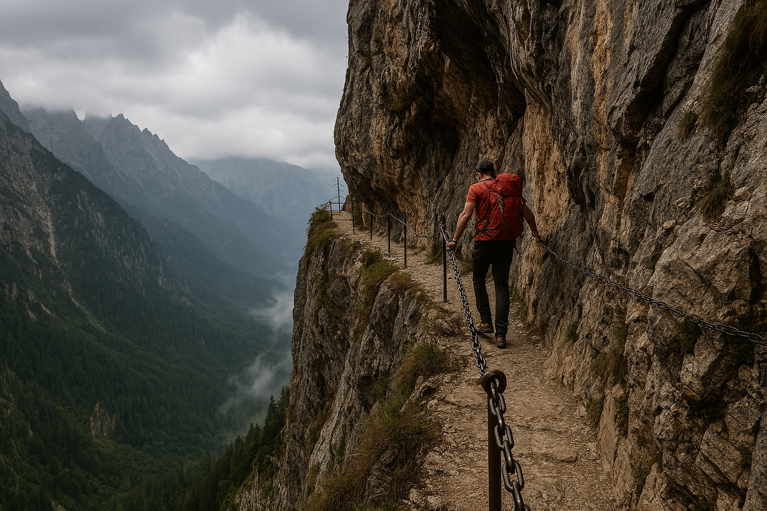
This is what most people think of first. We’re talking about knife-edge ridges, crumbling rock (what hikers call “scree”), and sections where you have to physically climb using your hands and feet. Some of the trails on this list feature a Via Ferrata (Italian for “Iron Path”), which is a route with steel cables, rungs, or ladders fixed to the rock. While these aid your climb, they often take you over massive, unprotected drops where a fall is absolutely not an option.
2. Extreme Weather
Nature moves fast, and on these trails, the weather is often your biggest enemy. In desert canyons, a storm miles away can trigger flash floods that turn a dry hiking path into a raging river in minutes. If you are hiking in narrow slots, you have nowhere to escape. On mountain peaks, temperatures can drop below freezing even in summer, leading to hypothermia before you even realize you’re cold.
-
Learn more about staying safe during flash floods from the National Weather Service.
3. Isolation
Some of these hikes are deep in the wilderness, far from the nearest road or ranger station. If you twist an ankle or run out of water here, you can’t just call an Uber. You are often in “dead zones” with zero cell service. This is why expert hikers always carry the 10 Essentials, including navigation tools and extra food, because rescue could be days away.
-
Check out this guide on Personal Locator Beacons vs. Satellite Messengers to see how pros call for help when their phones don’t work.
10 Trails That Will Test Your Limits
1. Mount Huashan: The Plank Walk (China)
If you are afraid of heights, you might want to stop reading right now. Located about 75 miles from Xi’an, China, Mount Huashan is one of the country’s “Five Great Mountains,” but it’s best known for a specific section that looks like something out of a video game: the Plank Walk in the Sky.
Description:
Imagine walking on creaky wooden boards that are only about a foot wide. Now imagine those boards are bolted into the side of a vertical cliff, 7,000 feet in the air. Oh, and there are no guardrails—just a chain you grip with sweaty palms and a harness that connects you to a safety wire. You have to walk out and back on the same path, which means unclipping your safety carabiner every time you pass someone coming the other way.
The Danger Factor: Extreme Heights.
While the harness system makes it safer than it looks, the psychological terror is real. A slip here without your gear secured would mean a fall into the abyss. There are rumors of accidents, though official numbers are hard to confirm. According to a detailed account by Canadian Geographic, the path is so narrow that you often have to step around other hikers while balancing on the edge of the void.
Vital Stats:
- Elevation: 7,087 ft (2,160 m) at the South Peak.
- Type: Via Ferrata (Iron Path).
- Learn More: Read more about the mountain’s history on Wikipedia.
2. The Maze District, Canyonlands (USA)
If you thought getting lost in a corn maze was frustrating, try getting lost in a 30-square-mile puzzle of red rock canyons where every turn looks exactly the same. Located in Utah, “The Maze” is the least accessible district of Canyonlands National Park. It is so remote that the rangers warn it can take up to three days for a rescue team to reach you if something goes wrong.
Description:
This isn’t a single trail; it’s a web of twisting canyons, towering fins, and dead ends. There are very few marked paths. You have to navigate using a paper map, a compass, and your own problem-solving skills.
The Danger Factor: Navigation & Isolation.
The biggest risk here isn’t falling off a cliff (though that’s possible); it’s making a wrong turn and running out of water. GPS units are notoriously unreliable in deep canyons because the rock walls block the satellite signal. You can walk for miles thinking you are on the right track, only to hit a wall and have to backtrack while your water supply drains away in the desert heat.
Vital Stats:
-
-
Risk: Dehydration and getting lost.
-
Requirement: 4WD vehicle just to reach the trailhead.
-
Learn More: Check out the official warning on the National Park Service website regarding self-reliance in The Maze.
-
3. Angel’s Landing (USA)
We are heading back to Utah for this one, specifically to Zion National Park. Angel’s Landing is easily one of the most famous stops on any tour of the world’s most dangerous hikes, but don’t let the pretty pictures on Instagram fool you. It gets its name because early explorers said only an angel could land on it, and frankly, they weren’t wrong.
Description:
The hike starts with a grueling set of switchbacks called “Walter’s Wiggles” that will definitely burn your calves. But the real challenge begins at Scout Lookout. From there, the trail turns into a steep, narrow fin of rock jutting out of the canyon. You have to scramble up a knife-edge ridge holding onto heavy metal chains bolted into the stone.
The Danger Factor: Crowds & Gravity.
The path is often only a few feet wide, with sheer 1,000-foot drops on both sides. Because it’s so popular, it can get crowded. Trying to squeeze past a terrified hiker while clinging to a chain over a massive drop is a recipe for disaster. Since 2004, at least 13 people have fallen to their deaths here.
Vital Stats:
-
-
Distance: 5.4 miles round trip.
-
Permit Required: Yes. Because it’s so popular, you now need to win a lottery to hike it.
-
Learn More: You can check the official permit lottery schedules and safety alerts directly at the National Park Service Angels Landing page.
-
4. Drakensberg Grand Traverse (South Africa)
If you want a hike that feels like a quest from The Lord of the Rings, this is it. The Drakensberg (which translates to “Dragon Mountains”) is a massive range that forms the border between South Africa and Lesotho. The “Grand Traverse” isn’t just a walk; it’s a full-blown expedition that requires you to be completely self-sufficient.
Description:
This is the ultimate test of endurance. There is no actual “trail” for most of the 140+ miles (220km). You are essentially following the edge of a massive escarpment, navigating by GPS and landmarks alone. You start the trek by climbing a terrifying set of chain ladders that dangle loosely against a vertical cliff face just to get onto the plateau.
The Danger Factor: The Chain Ladders & Isolation.
The initial climb up the Sentinel Peak chain ladders is mentally exhausting—one slip, and you are gone. But the real danger is being so far from help. You are days away from civilization, and the weather changes instantly from baking sun to freezing fog. If you get hurt here, you are on your own for a long time.
Vital Stats:
-
-
Distance: ~136 miles (220 km).
-
Time: 10–14 days.
-
Learn More: Check out the detailed route guide and safety tips at Hiking South Africa.
-
5. El Caminito del Rey (Spain)
For years, this trail held the unofficial title of “The World’s Most Dangerous Walkway,” and if you look at photos from ten years ago, you’ll see why. Located in Malaga, Spain, “The King’s Little Pathway” was a crumbling concrete path pinned to the sheer walls of the El Chorro gorge, originally built for hydroelectric workers in 1905.
Description:
This hike recently got a major safety upgrade, but it’s still terrifying. The new path is a wooden boardwalk pinned 100 meters (330 feet) up a vertical cliff face. The coolest (and creepiest) part? In many sections, you can look down through the glass floor or over the railing and see the old, destroyed path hanging in ruins right beneath your feet. It’s a constant reminder of how sketchy this place used to be.
The Danger Factor: Crumbling Infrastructure (Historically) & Vertigo.
Before the restoration in 2015, hikers had to balance on steel beams where the concrete had fallen away, leading to several tragic deaths. Today, the physical danger is much lower, but the mental challenge remains. If you freeze up at heights, being suspended on a boardwalk with a massive drop below is a nightmare scenario.
Vital Stats:
-
-
Height: ~330 ft (100m) above the river.
-
Length: 4.8 miles (7.7 km) total.
-
Learn More: You can book tickets and see the safety regulations on the official El Caminito del Rey website.
-
6. Cascade Saddle (New Zealand)
New Zealand is famous for its Lord of the Rings scenery, and this hike in Mount Aspiring National Park delivers exactly that. It connects the Matukituki Valley with the Dart Valley and offers some of the best alpine views on the planet. But unlike the movies, you don’t have Samwise Gamgee to pull you back up if you slip.
Description:
This is an alpine crossing that takes you high above the treeline. The views of the glaciers and Mount Aspiring (often called the “Matterhorn of the South”) are absolutely insane. However, the path is extremely steep and often involves scrambling with your hands.
The Danger Factor: “Slippery Tussock” (Grass).
This sounds ridiculous—how can grass be dangerous? In New Zealand, the alpine snow grass (tussock) is long and incredibly slick when wet. The trail passes over steep bluffs, and if you slip on the wet grass, it acts like a water slide that shoots you straight off a cliff. There is often nothing to grab onto to stop your fall. Because of this, the park rangers strongly recommend you only hike up the steep face, never down it, because it’s easier to keep your balance climbing up.
Vital Stats:
-
-
Location: Mount Aspiring National Park, South Island.
-
Season: Summer only (high avalanche risk in winter/spring).
-
Learn More: Read the specific warnings about the tussock and the route conditions on the Department of Conservation website.
-
7. Kalalau Trail (Hawaii, USA)
Most people go to Hawaii to lounge on the beach with a smoothie. But if you head to the Na Pali Coast on Kauai, you’ll find a trail that is as deadly as it is beautiful. The Kalalau Trail is an 11-mile trek through lush jungle and towering sea cliffs, but it demands total respect.
Description:
This isn’t a casual beach walk. The trail crosses five massive valleys before ending at the secluded Kalalau Beach. The most infamous section is Crawler’s Ledge (around mile 7). As the name suggests, the path gets so narrow and the drop-off into the ocean is so steep that many hikers end up crawling on their hands and knees just to keep from falling.
The Danger Factor: Flash Floods & Erosion.
While the cliffs are scary, the water is the silent killer here. Sudden tropical downpours can turn calm streams like Hanakāpīʻai into raging torrents in minutes. Hikers often get stranded on the wrong side of the river, and trying to cross the swollen water is the number one cause of accidents. Plus, the red clay mud turns into a slip-and-slide when wet, making those cliff edges even riskier.
Vital Stats:
-
-
Distance: 22 miles round trip.
-
Permit Required: Yes, for camping and hiking past Hanakāpīʻai Valley.
-
Learn More: Check the current stream conditions and permit rules on the Hawaii Division of State Parks official site.
-
8. Huayna Picchu (Peru)
You know that tall, pointy mountain photobombing every selfie at Machu Picchu? That isn’t just background scenery—you can actually climb it. Huayna Picchu overlooks the famous Inca ruins, and while the view from the top is legendary, the path to get there is notoriously sketchy.
Description:
This hike is short but incredibly intense. It involves climbing ancient Inca steps that are often slippery, uneven, and crumbling. The most famous section is terrifyingly nicknamed the “Stairs of Death.” These are floating stone steps that jut out of the wall at a near-vertical angle.
The Danger Factor: The Stairs of Death.
There are no handrails for large sections of this climb, just the rock wall on one side and a massive drop into the Urubamba River valley on the other. The gradient can hit 60%, meaning you are basically climbing a ladder made of wet stone. If you trip here, gravity will do the rest.
Vital Stats:
-
-
Elevation Gain: ~1,000 ft (300m) in just one mile.
-
Limit: Only 400 hikers allowed per day (tickets sell out months in advance).
-
Learn More: You can find official visitor information and ticket details on the Peru Official Tourism Board website.
-
9. Mount Washington (USA)
You might look at Mount Washington’s height (6,288 feet) and think, “That’s tiny compared to Everest!” But this peak in New Hampshire is proof that size doesn’t matter when it comes to danger. It is widely considered to have the “World’s Worst Weather,” and it has the body count to prove it.
Description:
Located in the White Mountains, this summit is accessible by car, train, and foot, which tricks many people into thinking it’s a casual day trip. But the weather here is volatile. It sits at the intersection of several storm tracks, creating a funnel for massive winds and sudden temperature drops. You can start hiking in 70°F sunshine at the base and face freezing rain and hurricane-force winds by the time you reach the top.
The Danger Factor: Erratic Weather.
Mount Washington held the world record for the fastest wind speed ever observed by man for decades: 231 miles per hour. That is faster than a Formula 1 car. The biggest killer here isn’t falling off a cliff; it’s hypothermia. Hikers often head up in shorts and t-shirts, get slammed by a sudden storm, and freeze to death even in the middle of summer because they didn’t pack warm layers.
Vital Stats:
-
-
Record Wind: 231 mph.
-
Average Temp: Below freezing for much of the year.
-
Learn More: Before you go, check the Mount Washington Observatory’s “Hike Safe” page to see why you need winter gear in July.
-
10. Kokoda Track (Papua New Guinea)
This isn’t just a hike; it’s a pilgrimage through history that doubles as a survival course. The Kokoda Track is a 60-mile narrow path through the dense jungles of Papua New Guinea, famously used during World War II. It connects the southern and northern coasts of the island, and it is absolutely relentless.
Description:
Imagine walking on a Stairmaster in a sauna for ten days straight. The track cuts through the rugged Owen Stanley Range, meaning you are constantly climbing steep, muddy peaks or sliding down them. You will cross raging rivers on slippery log bridges and trek through thick rainforest where the humidity hits 90%.
The Danger Factor: Disease & Endurance.
While the terrain is brutal, the invisible threats are worse. The jungle is a hotbed for tropical diseases like malaria. You face scorching heat during the day and freezing temperatures at night. If you get sick or injured here, evacuation is extremely difficult and expensive, often requiring a helicopter. It is a mental and physical punisher that breaks even fit athletes.
Vital Stats:
-
-
Distance: 60 miles (96 km).
-
Time: 8–12 days.
-
Learn More: Explore the history and permit requirements on the official Papua New Guinea Tourism website.
-
Essential Survival Gear for Extreme Hiking
When you are tackling the world’s most dangerous hikes, your standard school backpack and a bottle of water aren’t going to cut it. The margin for error on these trails is razor-thin, and having the right equipment is often the only thing standing between a cool story and a rescue helicopter. Here is the non-negotiable gear you need to survive.
Satellite Beacons (Your “Get Out of Jail Free” Card)
Let’s be honest: your smartphone is an amazing tool, but on trails like the Drakensberg Grand Traverse or in the depths of The Maze, it’s basically just a heavy camera. There is zero cell service. If you break a leg or get lost, you need a way to call for help that doesn’t rely on cell towers.
-
The Fix: You need a Personal Locator Beacon (PLB) or a Satellite Messenger (like a Garmin inReach). These devices blast a distress signal directly to search and rescue satellites from anywhere on Earth.
-
Learn More: Read the guide on How to Choose a PLB or Satellite Messenger from the experts at REI.
Footwear: Traction is Everything
Wearing gym sneakers on a trail like Angel’s Landing is a terrible idea. You need “grip” (traction) to stick to slick rock surfaces.
-
The Fix: For steep, rocky hikes, look for “Approach Shoes.” These are a hybrid between a hiking boot and a climbing shoe, designed specifically to stick to rock like glue. If you are hiking in mud or jungle (like the Kokoda Track), you need boots with deep “lugs” (the teeth on the bottom of the sole) to stop you from sliding off the edge.
-
Learn More: Check out the American Hiking Society’s guide on Hiking Boots vs. Trail Shoes to see what fits your trip best.
Hydration Systems (Filtering, Not Just Carrying)
Water is heavy (8 lbs per gallon!), and on long treks, you simply can’t carry enough for days at a time. You will eventually have to drink from a stream or a puddle.
-
The Fix: Never drink untreated water, no matter how clean it looks. Bacteria like Giardia can take you out of the game fast. You need a reliable filtration system—either a pump filter, a squeeze filter, or purification tablets as a backup.
-
Learn More: The CDC has a breakdown of the most effective Water Treatment Options for Hikers so you don’t get sick in the wild.
How to Prepare Mentally and Physically
You can’t just wake up one Saturday and decide to hike the world’s most dangerous hikes. That’s a fast way to end up on the news for all the wrong reasons. These trails require you to train your body to handle abuse and your brain to make smart choices under pressure.
Physical Training: Don’t Skip “Leg Day”
Most people train for hiking by walking uphill on a treadmill. That’s great for your cardio, but on trails like the Kokoda Track or Huayna Picchu, the downhill sections are what actually destroy you. Walking down steep gradients puts massive pressure on your knees and quads.
-
The Fix: Focus on Eccentric Training. This means strengthening your muscles while they are lengthening (like the “lowering” part of a squat). This prepares your legs to act as brakes on steep descents without turning to jelly.
-
Learn More: Check out this guide on How to Walk Downhill to see why “eccentric” strength saves your knees.
Mental Training: Beating “Summit Fever”
This is the most dangerous psychological trap in hiking. Summit Fever is when you are so focused on reaching the top that you ignore obvious warning signs like bad weather or exhaustion. You think, “I’ve come this far, I can’t turn back now!” That mindset kills people.
-
The Fix: Set a strict “Turn-Around Time” before you even start the car. For example: “If we haven’t reached the summit by 1:00 PM, we turn around, no matter how close we are.” Stick to the plan, not your ego.
-
Learn More: Read about how Summit Fever Has a Body Count and how to spot the signs before it’s too late.
Conclusion
There you have it: a tour of the world’s most dangerous hikes without even having to leave your chair. These trails offer some of the most spectacular views on Earth, but they demand a level of respect that most weekend adventures don’t.
If you ever decide to tackle one of these beasts, remember that the mountain will always be there next year. There is no shame in turning around if the weather gets bad or you’re just not feeling it. The best hikers aren’t the ones who take the biggest risks; they are the ones who make it home to tell the story.
Frequently Asked Questions (FAQ)
Q: Which hike on this list is actually the deadliest?
A: It is hard to give an exact number because many countries don't release official accident statistics. However, Mount Huashan in China is often rumored to have a very high accident rate, though this is unconfirmed. In the US, Angel’s Landing and Mount Washington have well-documented fatalities due to falls and weather, respectively.
Q: Do I need special insurance for these hikes?
A: Absolutely. Most standard travel insurance policies explicitly exclude "extreme sports" or hiking above a certain elevation (usually around 3,000 meters or 9,800 feet). If you need a helicopter rescue on the Kokoda Track or in the Drakensberg, it could cost you tens of thousands of dollars out of pocket. Look for policies that specifically cover "adventure sports" or "search and rescue."
Q: Can beginners attempt any of these hikes?
A: Most of these are not for beginners. However, some can be done if you hire a professional guide. For example, the Kokoda Track is almost always done with a guided tour company that provides food, porters, and medical support. But for trails like The Maze or Cascade Saddle, you need independent navigation skills and high-level fitness before you even think about packing your bag.
Q: Are these trails open year-round?
A: No. Many of these trails are seasonal. The Cascade Saddle in New Zealand is extremely dangerous in winter and spring due to avalanche risk. Mount Washington is accessible in winter, but only for mountaineers with ice axes and crampons. Always check the specific park website for seasonal closures before booking your trip.